

The town of Kardzhali is situated along both banks of the Arda River in a small valley in the Eastern Rhodope Mountains. Kardzhali has a population of 42 000 inhabitants. The town lies at a distance of 259 km from Sofia. Kardzhali is a district and municipal administrative centre of 117 settlements. The district is a unique combination of historic monuments from ancient times and natural phenomena.
Traces of the prehistoric, Thracian and Roman culture were discovered in the region of Kardzhali. Undoubtedly the sacred Thracian site Perperikon is of the greatest interest. The sanctuary lies at a distance of 20 km from Kardzhali, 2 km from the village of Gorna Krepost and 6 km from the village of Perperek. The evidence of human activity in the complex dates back to V-IV c. B.C. The excavations show that a huge palace of several floors was built on the site over the rocky formations. During the Middle Ages the palace was often transferred from the Bulgarian to the Byzantine limits and back. The remains of the medieval town of Monyak were discovered in the Veselchane quarter. The architecture of the town is like the one of Preslav, Mesembria and Turnovo. The settlement was conquered by the Turks in 1379. In 1607 the settlement was registered in the Ottoman documents under the name of Kardzhala. In 1878 Russian Kazakhs led by general Chernobuzov liberated the town which according to the Berlin Peace Contract remained within the limits of the vassal principality of East Roumelia. Kardzhali went back to the limits of Bulgaria on 8th October 1912.
The tourist sights of the town are: The History Museum, the medieval monastery complex "St. Yoan Predtecha", the temple "St. Georgi", remains from the medieval fortress Monyak.
Other cultural-historic sights on the territory of the district are: the medieval fortresses Kaleto, Ustra, Vishegrad and Asara.
The most famous natural landmarks of the region are: the reserves "Valchi Dol", "Kazalcherpa", "Borovetz", "Chamlaka"; the rocky formations - "Kardzhali Pyramids", "Vkamenena gora" /Petrified forest/ and "Vkamenena svatba" /Petrified wedding/. The dam-lake " Studen Kladenetz" and the Krumovitza River are included in the Corine Programme and are important ornithological sites of the region.
Tourist sights
The rocky town of Perperikon lies at a distance of 15 km northeast of the town. The local people call the rocky peak with the name of "The Spirits' peak". The rocky massif has been deified ever since the Neolith at the end of VI c. and the beginning of V c. B.C. and was used for different purposes until XIV c. Perperikon is an abbreviation of the full name of Hiperpirakion(Hiperperakion), known from the Byzantine written sources from XIII-XIV c. This is a Greek word consisting of two parts - "hiper", meaning "extra" and "piros", meaning "fire". The word "hiperpirgos" was used by Aristotle and his followers and was related to cult activities and more precisely to fire rituals performed over the altar. One of the hypotheses is that the sacred town has had this name since then. However, no written evidence about that was found. On a map from 1801 done by the topographer Josef Romen Jolie from the Napoleon headquarters the lines of the Balkan Peninsula, the coastal lines and the location of rivers and towns are as accurate as on the present-day maps. On this map the town of Pergamon is marked along the middle current of the Arda River where is located the present-day town of Kardzhali. While Kardzhali town is marked at the eastern end of the Besika land where now stands the present-day Perperikon. Pergamon and pergamos are Thracian words which in the past meant several things:
- tower, fortress, acropolis
- The sacred Citadel of Troy - in the last decades of the XI c. B.C. the famous movement of the Thracian people took place in Troy. The contacts between the Troy and Thrace never stopped during the whole II millennia B.C.
- A town in Mizia
Perperikon was strongly fortified at these times and was also called Pergamon. According to the archaeologists there is a third name of the sacred town - Zilmisos. According to some information from Ambrosii Teodosii Makrobii the main temple of the ancient God of Dionysius was located on the Zilmisos hill. A Roman historian reported that for the ancient Thracian people the main cult was towards the God of the Sun. In this famous sanctuary people paid respect to the god of the sun Apollonius during the day and to Dionysius during the night. Apollonius and Dionysius are the other two cults for the Thracian people apart from their cult to the Sun. The contemporary scientists have proved that behind the names of these two Greek Gods are hidden the names of ancient Thracian deities. The ancient Greek legends tell about the Dionysius sanctuary - the Sacred Rhodope Mountains. The sanctuary was located in a vast oval-shape hall without any roof which was necessary because of the nature of the rituals performed inside. The sorcerer of the sacred place of Dionysius did at last two important prophesies for the humanity - those about Alexander the Great and Julius Cesar.
The temple of the great mother goddess - on the territories of the villages of Nenkovo, Zhenda and Dazhdovnitza in the district of Kardzhali is a specific megalithic temple of the Great mother goddess where the culminations of the Orphic sacraments were performed. The temple is located on a high plateau at the Tangardak Kaya site, meaning "the rattling rock". The cult towards the great mother goddess was worshiped in the very centre of the sacred Thracian mountains. The historic sources mention two such mountains - Pangei, which is one of the names of Rhodope Mountains and Kogayon farther northeast in the land of the Getty tribes. The sacred Thracian mountains had a precise analogy to the mountains of Mala Asia - Ida Mountains in Frigia and Tmol Mountains in Midia. The caves of these mountains were used by prophets, semi-gods and antropodemons. For the Rhodope Mountains such were considered to be Orpheus and Rezus and for the sacred place of the Getty tribes - Zalmoksis.
The sanctuary is in the shape of a vulva with a length of 22 m. At noon a sun phallus is formed from a special opening of the cave pointing towards the internal part of the altar - the womb. Only during the shortest winter days the phallus reaches the womb and "impregnates" it. In the middle of the vault there is a semi-spherical niche and when one speaks right under it a supernatural voice is heard all over the sacred place. That is why the local people gave the sanctuary the name of the Rattling rock.
The Tatul megalithic monument in the village of Tatul remained unknown until 2005 when it was discovered during archaeological excavations. The rocky formation can be seen from kilometers. It has the shape of a truncated pyramid and is obvious that it is man-made. On the top it is elaborately leveled in a horizontal platform where a man can climb. Here a tomb was hewn which was a major object of worships. Decades before there are hypotheses that the tomb of Orpheus with a temple next to it is located in the vicinity of the village. The excavations show Tatul as a 4 000-year-old significant cult centre for the whole Mediterranean region. According to the ancient beliefs the Thracian leaders turn into godlike humans and antropodemons after their death. They were buried at specially chosen places which were worshiped as sanctuaries. The condition of an antropodemon was transitory and after a while the dead kings became true god heroes. The names of such sanctuaries are heroons. At Tatul's heroon were buried the relics of a great Thracian king whose name was well known along the Rhodope Mountains and whole Thrace. The historical data points out that it is possible that he is one of the heroes of the Trojan War for many Thracian kings took place in that war. The ancient Greek poet Homer mentioned the names of the rulers of the South Rhodopean region - Rezos, son of Eyone - the king of the bistons and Peyroy, son of Imbras who governed the Thracian lands along the Maritza River. Some battled on the side of the Trojans other on the side of the Greeks but they are all known as great heroes such as Achilles, Hector, Odysseus and many other.
The medieval fortress of Monyak lies at a distance of 4 km east of the district town. The fortress has had a protected area of 5 hectares. From the fortress are preserved the external fortified wall, the towers, some water-storage basins, a pottery water-conduit and other. Military units were deployed in the Monyak fortress. The fortress dates back to XII and the beginning of XIII centuries.
The Stremtzi Gold Mines in the village of Stremtzi - this is the oldest preserved gold mine in Europe. There are more than ten entrances and galleries longer than 500 m. The most precious coin of the Middle Aged is related to the gold mines of Stremtzi - the twenty-two-carat hiperperon, known as the "perpera".
The History Museum in Kardzhali is in an oriental-style building designed by the Russian architect Pomerantzev. The museum was established in 1965 and its collections are divided into three groups: historic, ethnographic and mineral. The museum possesses more than 37 000 precious objects.
The Art Gallery in Kardzhali has a collection of precious icons, Revival period prints, paintings, graphics and sculptures. Among the artists whose art works are displayed at the museum are: Svetlin Russev, Vladimir Dimitrov Maistora (the Master), Kiril Tzonev, Dechko Uzunov.
The Monastery complex "St Yoan Predtecha" in Kardzhali was built over the foundations of an ancient temple. The monastery was a bishop's centre of the Ahridos district during the Middle Ages. It is one of the significant medieval monuments built in XI-XIV c. It was also a bishop's residence. During archaeological excavations in 1998 was found a tomb with bishop's clothes which were restored and preserved. They are made of silk with gold embroidery. The monastery "St. Yoan Predtecha" was restored in 2000.
The Cromlech in the village of Dolni Glavanak is a group of dug into the ground stone blocks forming huge circles. The most famous cromlech in the world is Stonehenge in England. The date of origin of the cromlech is arguable because of the scarce archaeological findings around it.
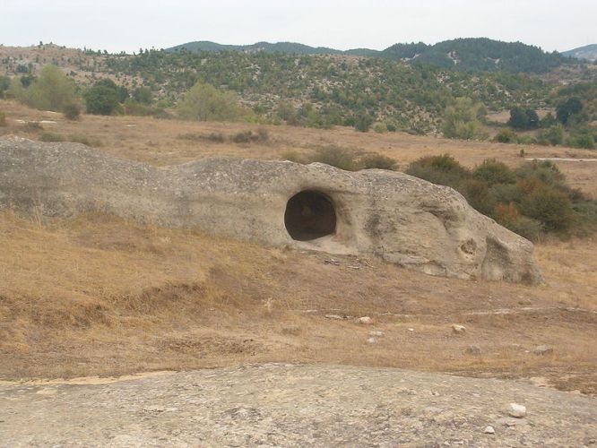
Thracian tomb, village of Benkovski
The village of Benkovski in Kardzhali district is rich of archaeological findings of the so-called "civilization of the rocky people". In the region there are natural rocky formations, deified by the people, basins, gullies, rocky tombs and other rocky figures.
The Rocky tombs in the district of Kardzhali are one of the main symbols of the civilization of the rocky people. In Eastern Rhodope Mountains there are no mound necropolises typical for the Thracian valley, the White Sea Region and Northern Bulgaria. However, here were discovered unique rocky tombs along the Arda River valley. Their number is 42, which are distributed in three regions. The first region is a group of 11 tombs on the territories of the villages of Pchelari, Dolno Cherkovishte, Potochnitza and Strazhevo. The second region is by the villages of Tatul, Nanovitza and Raven with 4 tombs. The third region has 15 rocky tombs in the region of the villages of Ovchevo, Vodenicharsko, Samodiva, Podkova, Mazhentzi and the Yagnevo neighbourhood of the village of Benkovski. The rocky tomb chambers have the shape of a truncated pyramid or of a dome-shaped ceiling. The foundation of the tombs is either round or square. Some of the tombs have a narthex, others don't. The flutes for the stone doors have been preserved on some of the tombs. In the interior of the tombs there are additional elements such as niches, burial platforms etc.
The rocky niches in Kardzhali District are one of the strangest and inexplicable phenomena of the megalithic culture of the Eastern Rhodope Region. There are more than 1500 niches divided into 130 groups. The groups vary from having 3-4 to 100 monuments. The niches are hewn very high on well-shaped rocks or mountainous massifs in hard-to-reach places most often on the sun-lit side of the slopes. Predominantly there are trapeze-shaped niches with a height of 0,60-1,00 m and depth of 0,45 m. There are also bigger niches of up to 2 m height and depth of 1,50 m. Their distribution repeats the distribution of the rocky tombs. There are rocky niches on the territories of the villages of Dolno Cherkovishte, Dzhankata, Dazhdovnitza, Strandzhevo and other settlements.
The rocky basins /sharapani/ in the Kardzhali region are of round or square shape connected to canals and overflow drains. The word sharapani in Turkish means grapes-squeezing presses used for the manufacture of wine. They are the most widely spread megalithic monuments and one can see them in hundreds of high places in the region following the other rocky formations. Some historians believe the sharpani are altars on which the Thracian kings performed sacrifices and the sacrificial blood ran along the gullies. The latest research shows that they were used for the manufacture of ritual wine connected to the cult towards the Thracian god Dionysius.

The Thracian sanctuary at Tatul Village
The town of Momchilgrad has a population of 7 900 inhabitants and lies at a distance of 16 km south of Kardzhali. The town is the centre of a municipality of 48 settlements. Until 1934 the town was known as Mastanli. The region around Momchilgrad is rich in poly-metal ore deposits. There are findings from the Neolith, the Eneolith and the Bronze Age in the region. Near the town is located the second most important sanctuary for the Thracian people - the sanctuary near Tatul. There can be seen remains of religious Thracian buildings. Some of them are preserved in an excellent condition.
The town of Ardino has a population of 3 700 inhabitants and is the centre of a municipality of 52 settlements. The town lies at a distance of 35 km southwest of the district town.
The first written source for the town of Ardino are the memoirs of the French explorer August Vikenel from 1847. The old name of the town is Iridere. In 1934 the town took the name of Ardino.
The tourist sights on the territory of the municipality are: The Devil's Bridge, the medieval fortress "Krivus", the Thracian sanctuary "Orlovi Skali" and the Thracian fortress "Kaleto"
The Devil's Bridge at the village of Dyadovtzi is situated over the Arda River. The bridge is preserved in perfect condition. It is 65,7 m long, 3,40 m wide and 8,5 high at the middle vault. The road connecting present-day Plovdiv with the White Sea Region passed through it. The bridge has three vaults with breakwaters against the current. On one of the key stones of the vault there is a sign saying "hexagon".
The "Krivus" fortress at the village of Bashevo was mentioned by the Byzantine annalist Georgi Akropolit. It was built on a steep hill surrounded by the Arda River at its three sides. At the southern side there is a citadel -castle. The fortress was supplied with water from the Arda River through an underground tunnel.
The "Orlovi Skali" sanctuary lies at a distance of 2 km from the town of Ardino. There are 97 niches hewn in the high rocks with sizes of 32x45x20 cm. They are 8-12 cm deep. It is supposed that ritual slabs or pottery was placed in them related to the cult towards the dead.
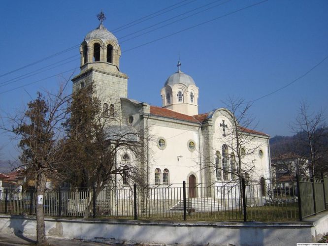
Church, the town of Krumovgrad
The town of Krumovgrad has a population of 5 200 inhabitants and is the centre of a municipality of 78 settlements. The town lies at a distance of 49 km from the district town of Kardzhali. It is situated along both banks of the Krumovitza River in the Eastern Rhodope Mountains. Until 1943 the town was known under the name of Kushu Kavak. There are deposits of lead-zinc ores, asbestos and mica. Krumovgrad is the centre of a tobacco manufacturing region. There are remains of the ancient times in the region.
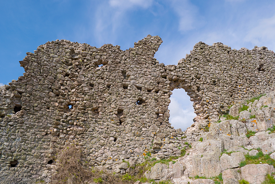
The Ustra Fortress, Dzhebel municipality
The town of Dzhebel has a population of about 3000 inhabitants and is the centre of a municipality of 47 settlements. The town lies at a distance of 20 km south of Kardzhali. There are remains of a Thracian settlement and a medieval fortress in the region of the town. Until 1934 the town was known under the name of Sheh Dzhumaya. The municipality is specialized in the tobacco manufacture.
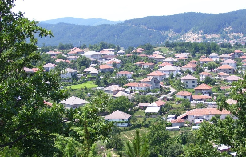
The village of Kirkovo
The village of Kirkovo is the centre of a municipality in the Kardzhali District with 72 component settlements. The village lies at a distance of 45 km from the district town of Kardzhali in the Eastern Rhodope Mountains. The region is specialized in the tobacco manufacture.

The village of Chernoochene
The village of Chernoochene is an administrative centre of 50 settlements in the Kardzhali District. The village lies at a distance of 21 km north of Kardzhali along the Pererek River. The region is specialized in the tobacco manufacture and the fruit-growing.


